Maps.
Map are liminal texts, describing something of the place, but never the place itself.
I was curious; since NASA and Apollo space missions we learn that our world is a ball of rock, spinning around the sun, spinning through space. Each of us stuck to the ground through our feet, heads pointing towards the universe.
Even though it doesn't really feel true..there is considerable evidence that it is true.
Yet some people resist and maintain an older, image of the world: the world as a flat disc, or the earth as a hollow sphere.
Other people- often scientists- believe reality to be made of at least thirteen thousand layers.
Well, as far as I'm concerned, all versions work at walking speed.
Believe what you will, but only one can take you to stand on the Moon.
I wanted to find the oldest map.
It may be possible some Neolithic some rock art- cup and ring- represents a sacred landscape. This seemed to be the case with one stone at Newgrange; and I'm sure that there are older. But there is no written history for then.
How about the Sumerians?
We have fragments of their mythology and we know where their cities were...
I couldn't find a Sumerian map.
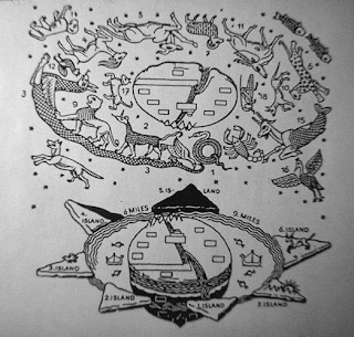
The oldest is this one.
This map dates from the Persian Period (early 5th century B.C.), shows a flat, round world with Babylonia in the center.
Text on the back mentions seven outer regions beyond the encircling ocean.
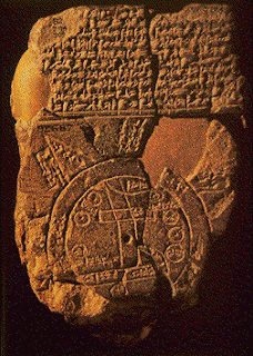
The image isn't too incomprehensible:
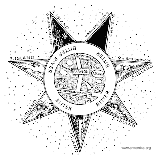 The map is oriented NW which is the direction of the prevailing wind: the wind Ishtar sends. People try to fill in the gaps in the broken cuneiform map so that it may be read, most take the star-points to be islands. The tablet states that these 'islands' are at equal distances of seven miles (from either each other or from the Babylonian world?), around the outer periphery of the Earthly Ocean.
The Seven Islands (though there may be eight?)- differ in how much light there is there.
The North island (5) is in darkness - a land "where one sees nothing," and "the sun is not visible.
The North-West (4) island "the light is brighter than that of sunset or stars"
The third island (3) is where "the winged bird ends not his flight," in other words, cannot be reached.
The North-East island (6) is "where a horned bull dwells and attacks the newcomer". An exactly similar presentation occurs in the same position in an astrolabe of the 17th century A.D. and has been used in the reconstruction of the tablet.
The seventh island (7) is the east and is is "where the morning dawns," meaning that it faces the sunrise. Again, the islands are all "seven miles" distant from the earth, but the distance between them varies, being sometimes six, sometimes nine miles.
The description of two more islands has not survived.
On the other hand, it is more reasonable to think that the islands may be mountains...
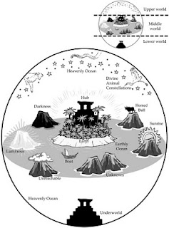
This next map preserves the idea of islands and adds the underworld directly under the earth, the 'Bitter river' seems to flow into it.
The next map shows mountains and is perhaps the best of the modern interpretations:
The earth is a flat disc, surrounded by mountains and floating on an ocean of sweet water. Resting on these mountains is the hemispherical vault of the sky, across which moves the stars, the planets, the sun and the moon.
Under the earth there is another hemisphere, the underworld, a reflection of the upper world. Whilst the whole spherical world-universe floats like a bubble in a limitless ocean of salt water..
I was curious; since NASA and Apollo space missions we learn that our world is a ball of rock, spinning around the sun, spinning through space. Each of us stuck to the ground through our feet, heads pointing towards the universe.
Even though it doesn't really feel true..there is considerable evidence that it is true.
Yet some people resist and maintain an older, image of the world: the world as a flat disc, or the earth as a hollow sphere.
Other people- often scientists- believe reality to be made of at least thirteen thousand layers.
Well, as far as I'm concerned, all versions work at walking speed.
Believe what you will, but only one can take you to stand on the Moon.
I wanted to find the oldest map.
It may be possible some Neolithic some rock art- cup and ring- represents a sacred landscape. This seemed to be the case with one stone at Newgrange; and I'm sure that there are older. But there is no written history for then.
How about the Sumerians?
We have fragments of their mythology and we know where their cities were...
I couldn't find a Sumerian map.
The oldest is this one.
This map dates from the Persian Period (early 5th century B.C.), shows a flat, round world with Babylonia in the center.
Text on the back mentions seven outer regions beyond the encircling ocean.

The image isn't too incomprehensible:

The Seven Islands (though there may be eight?)- differ in how much light there is there.
The North island (5) is in darkness - a land "where one sees nothing," and "the sun is not visible.
The North-West (4) island "the light is brighter than that of sunset or stars"
The third island (3) is where "the winged bird ends not his flight," in other words, cannot be reached.
The North-East island (6) is "where a horned bull dwells and attacks the newcomer". An exactly similar presentation occurs in the same position in an astrolabe of the 17th century A.D. and has been used in the reconstruction of the tablet.
The seventh island (7) is the east and is is "where the morning dawns," meaning that it faces the sunrise. Again, the islands are all "seven miles" distant from the earth, but the distance between them varies, being sometimes six, sometimes nine miles.
The description of two more islands has not survived.
On the other hand, it is more reasonable to think that the islands may be mountains...
This next map preserves the idea of islands and adds the underworld directly under the earth, the 'Bitter river' seems to flow into it.

The next map shows mountains and is perhaps the best of the modern interpretations:
The earth is a flat disc, surrounded by mountains and floating on an ocean of sweet water. Resting on these mountains is the hemispherical vault of the sky, across which moves the stars, the planets, the sun and the moon.
Under the earth there is another hemisphere, the underworld, a reflection of the upper world. Whilst the whole spherical world-universe floats like a bubble in a limitless ocean of salt water..