3 AM.
The road only exists where there is light.
Deserted roads all leading towards the cold light of dawn.
Colour is absent, only a memory. Sometimes just a smudge or impression of green.
Only the gold sodium lights have any true colour.
Eventually the moon leads the way.
The impression of greens and blues become stronger and our way is strewn with ribbons of frothy white flowers growing besides hedges and on the verges of long, long roads that lead to Marlborough.
Beyond Marlborough the colours have seeped into the landscape; muted and low key.
No one is awake.
No traffic -all the houses dark, curtains closed, shops all shut up.
But the sunlight is beginning to spill.
Crimson and orange burn a hole in the clouds.
5 AM.
The wind is ferocious, this dawn colder than midwinter.
We arrive.
My fingers turning pink and stiff in the icy air I wonder why I always forget to bring thin gloves. The alternative- dysfunctional fingers locked up in thick leather, motorbike gloves or pink little fingers...cooling to a point of immobility?
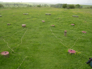
I take photographs.
I lay out string.
I take more photos.
I'm perplexed.
The north east path does not lead to the sun unless I'm standing in the outer ring.
Absolutely, empirically the midsummer Sun doesn't shine down the 'sun-path'...
Unless there is something about the pillars that changes where the line appear to end.
Damn, why didn't I learn technical drawing!.

It still wouldn't work for anyone standing at the center of the structure (I don't think...) but the center wasn't easy to get to, it seems to be have been blocked off.
If the center is the imaginary active part, why would anyone want to stand in the heart of the workings?
We walk up the Ridgeway for a while and sit.
I'm eating Parma Violets as I write.

8:30 AM.
Back in Marlborough.
Polly Tea Rooms are closed due to an electrical fault..
So we go the The Castle and Ball.
Where I had an indescribably delicious breakfast -after the coffee.

3:30 PM
Avebury and I need sun block!

5PM.
We have been frozen by the dawn, boiled by the midday sun and now we return so I can record the angles of each path.
It is full of people; gamboling, sitting.
Two people hand in hand are skipping around the edge.
A party.
As we get closer they really seem to just evaporate; there was no coach.
No cars in the lay-by.
Where did they go?
I try to lay out the string once more.
By the time I get to north-west I've really 'lost my thread'.
The Eastern side is fairly easy to do, but the Western side is really messed up.
By the end I've lost the scissors and my head is spinning.
Annoyed by that clear diagram in Avebury museum...
But here, now in the real place the arrangement of markers does not correspond to the diagram.
As I took the compass readings my heart was sinking. All the paths (except two) end in a compass reading that ends with a zero. I can see the stumpy little concrete posts being laid out by The Ministry of Work; possibly with a compass and theodolite to create a neat and tidy representation of a prehistoric monument.
Please tell me it wasn't so!
But at least I found my scissors again.
 Post script.
I asked Josh Pollard about the Cunnington's Sanctuary plan.
His reply:
Deserted roads all leading towards the cold light of dawn.
Colour is absent, only a memory. Sometimes just a smudge or impression of green.
Only the gold sodium lights have any true colour.
Eventually the moon leads the way.
The impression of greens and blues become stronger and our way is strewn with ribbons of frothy white flowers growing besides hedges and on the verges of long, long roads that lead to Marlborough.
Beyond Marlborough the colours have seeped into the landscape; muted and low key.
No one is awake.
No traffic -all the houses dark, curtains closed, shops all shut up.
But the sunlight is beginning to spill.
Crimson and orange burn a hole in the clouds.
5 AM.
The wind is ferocious, this dawn colder than midwinter.
We arrive.
My fingers turning pink and stiff in the icy air I wonder why I always forget to bring thin gloves. The alternative- dysfunctional fingers locked up in thick leather, motorbike gloves or pink little fingers...cooling to a point of immobility?
I take photographs.
I lay out string.
I take more photos.
I'm perplexed.
The north east path does not lead to the sun unless I'm standing in the outer ring.
Absolutely, empirically the midsummer Sun doesn't shine down the 'sun-path'...
Unless there is something about the pillars that changes where the line appear to end.
Damn, why didn't I learn technical drawing!.

It still wouldn't work for anyone standing at the center of the structure (I don't think...) but the center wasn't easy to get to, it seems to be have been blocked off.
If the center is the imaginary active part, why would anyone want to stand in the heart of the workings?
We walk up the Ridgeway for a while and sit.
I'm eating Parma Violets as I write.

8:30 AM.
Back in Marlborough.
Polly Tea Rooms are closed due to an electrical fault..
So we go the The Castle and Ball.
Where I had an indescribably delicious breakfast -after the coffee.

3:30 PM
Avebury and I need sun block!

5PM.
We have been frozen by the dawn, boiled by the midday sun and now we return so I can record the angles of each path.
It is full of people; gamboling, sitting.
Two people hand in hand are skipping around the edge.
A party.
As we get closer they really seem to just evaporate; there was no coach.
No cars in the lay-by.
Where did they go?
I try to lay out the string once more.
By the time I get to north-west I've really 'lost my thread'.
The Eastern side is fairly easy to do, but the Western side is really messed up.
By the end I've lost the scissors and my head is spinning.
Annoyed by that clear diagram in Avebury museum...
But here, now in the real place the arrangement of markers does not correspond to the diagram.
As I took the compass readings my heart was sinking. All the paths (except two) end in a compass reading that ends with a zero. I can see the stumpy little concrete posts being laid out by The Ministry of Work; possibly with a compass and theodolite to create a neat and tidy representation of a prehistoric monument.
Please tell me it wasn't so!
But at least I found my scissors again.
 |
| Not praying. Lining things up! |

I asked Josh Pollard about the Cunnington's Sanctuary plan.
His reply:
The Cunnington's plan should be fairly accurate (to within 20cm or so), though it's worth noting that they took measurements on the centres of the post- and stone-holes rather than faithfully surveying their outlines.